🚚 Free Worldwide Shipping on All Orders!Shop Now
1 / 6
+1
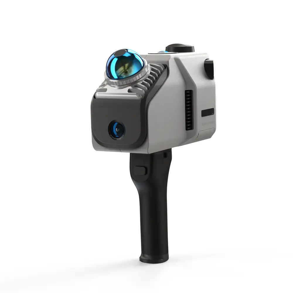
3DMakerpro Eagle LIDAR 3D Scanner
Professional Long-Range LIDAR 3D Scanning with RTK for Survey-Grade Precision
The 3DMakerpro Eagle with RTK Module is a state-of-the-art LIDAR 3D scanner designed for professionals who demand the highest level of positional accuracy in outdoor environments. With integrated RTK (Real-Time Kinematic) technology, this system delivers precise geo referenced 3D data—ideal for surveying, mapping, construction, and environmental research where exact spatial coordinates are critical.
What is RTK?
RTK (Real-Time Kinematic) is an advanced satellite positioning technology that significantly increases the accuracy of GPS data. With RTK, the Eagle scanner can achieve centimetre-level absolute positioning, ensuring your 3D scans are precisely aligned with real-world coordinates. This is essential for land surveying, GIS mapping, and any application where geospatial accuracy is required.
Key Features
- Long-Range LIDAR Scanning: Capture precise 3D data up to 200 meters (model-dependent)
- RTK Module for Survey-Grade Accuracy: Achieve true centimetre-level positioning and geo referenced data
- Outdoor Ready: Weather-resistant, rugged design for fieldwork and challenging environments
- High Accuracy: Ideal for professional surveying, mapping, and engineering
- Fast Data Capture: Rapid point cloud generation for efficient workflows
- Versatile Applications: Perfect for surveying, topography, construction, forestry, GIS, and more
- Multiple Export Formats: Seamless integration with CAD, GIS, and 3D modelling platforms
- User-Friendly Software: Powerful processing, visualisation, and export tools included
- Portable & Easy to Deploy: Lightweight and transportable for on-site scanning
- Worldwide Shipping: Fast delivery across Europe and globally
- 1-Year Manufacturer Warranty
Perfect For
- Land surveying and topographic mapping
- Construction site documentation
- Forestry and environmental research
- Infrastructure and civil engineering
- Archaeology and heritage preservation
- Outdoor 3D modelling and visualisation
- GIS mapping and geo referenced data collection
What’s in the Box
- 3DMakerpro Eagle 3D Scanner
- RTK Module
- Carrying Case
- Charging Accessories
- Calibration Tools
- User Manual
- Software License
Professional Long-Range LIDAR 3D Scanning with RTK for Survey-Grade Precision
The 3DMakerpro Eagle with RTK Module is a state-of-the-art LIDAR 3D scanner designed for professionals who demand the highest level of positional accuracy in outdoor environments. With integrated RTK (Real-Time Kinematic) technology, this system delivers precise geo referenced 3D data—ideal for surveying, mapping, construction, and environmental research where exact spatial coordinates are critical.
What is RTK?
RTK (Real-Time Kinematic) is an advanced satellite positioning technology that significantly increases the accuracy of GPS data. With RTK, the Eagle scanner can achieve centimetre-level absolute positioning, ensuring your 3D scans are precisely aligned with real-world coordinates. This is essential for land surveying, GIS mapping, and any application where geospatial accuracy is required.
Key Features
- Long-Range LIDAR Scanning: Capture precise 3D data up to 200 meters (model-dependent)
- RTK Module for Survey-Grade Accuracy: Achieve true centimetre-level positioning and geo referenced data
- Outdoor Ready: Weather-resistant, rugged design for fieldwork and challenging environments
- High Accuracy: Ideal for professional surveying, mapping, and engineering
- Fast Data Capture: Rapid point cloud generation for efficient workflows
- Versatile Applications: Perfect for surveying, topography, construction, forestry, GIS, and more
- Multiple Export Formats: Seamless integration with CAD, GIS, and 3D modelling platforms
- User-Friendly Software: Powerful processing, visualisation, and export tools included
- Portable & Easy to Deploy: Lightweight and transportable for on-site scanning
- Worldwide Shipping: Fast delivery across Europe and globally
- 1-Year Manufacturer Warranty
Perfect For
- Land surveying and topographic mapping
- Construction site documentation
- Forestry and environmental research
- Infrastructure and civil engineering
- Archaeology and heritage preservation
- Outdoor 3D modelling and visualisation
- GIS mapping and geo referenced data collection
What’s in the Box
- 3DMakerpro Eagle 3D Scanner
- RTK Module
- Carrying Case
- Charging Accessories
- Calibration Tools
- User Manual
- Software License
Select Version
From $1,769.86
Original: $5,056.74
-65%3DMakerpro Eagle LIDAR 3D Scanner—
$5,056.74
$1,769.86Description
Professional Long-Range LIDAR 3D Scanning with RTK for Survey-Grade Precision
The 3DMakerpro Eagle with RTK Module is a state-of-the-art LIDAR 3D scanner designed for professionals who demand the highest level of positional accuracy in outdoor environments. With integrated RTK (Real-Time Kinematic) technology, this system delivers precise geo referenced 3D data—ideal for surveying, mapping, construction, and environmental research where exact spatial coordinates are critical.
What is RTK?
RTK (Real-Time Kinematic) is an advanced satellite positioning technology that significantly increases the accuracy of GPS data. With RTK, the Eagle scanner can achieve centimetre-level absolute positioning, ensuring your 3D scans are precisely aligned with real-world coordinates. This is essential for land surveying, GIS mapping, and any application where geospatial accuracy is required.
Key Features
- Long-Range LIDAR Scanning: Capture precise 3D data up to 200 meters (model-dependent)
- RTK Module for Survey-Grade Accuracy: Achieve true centimetre-level positioning and geo referenced data
- Outdoor Ready: Weather-resistant, rugged design for fieldwork and challenging environments
- High Accuracy: Ideal for professional surveying, mapping, and engineering
- Fast Data Capture: Rapid point cloud generation for efficient workflows
- Versatile Applications: Perfect for surveying, topography, construction, forestry, GIS, and more
- Multiple Export Formats: Seamless integration with CAD, GIS, and 3D modelling platforms
- User-Friendly Software: Powerful processing, visualisation, and export tools included
- Portable & Easy to Deploy: Lightweight and transportable for on-site scanning
- Worldwide Shipping: Fast delivery across Europe and globally
- 1-Year Manufacturer Warranty
Perfect For
- Land surveying and topographic mapping
- Construction site documentation
- Forestry and environmental research
- Infrastructure and civil engineering
- Archaeology and heritage preservation
- Outdoor 3D modelling and visualisation
- GIS mapping and geo referenced data collection
What’s in the Box
- 3DMakerpro Eagle 3D Scanner
- RTK Module
- Carrying Case
- Charging Accessories
- Calibration Tools
- User Manual
- Software License